Fri 20 January 2006
Most commercial software comes with fairly elaborate geocoding engines and there are nice geocoding services on the web that can do one-at-a-time geocoding but the recent post at Spatially Adjusted pointed out a great free resource for batch geocoding named, conveniently enough, Batch Geocode. Just give it a list of tab or pipe delimited addresses and it outputs a table with your original data plus a lat/long for every row.
I have been working on a python script to convert text files into point shapefiles and thought this would be a great chance to put it to work. The only dependency is a recent version of python with the ogr module (see FWTools for an easy to install package for windows or linux).
First, I take a list of cities and feed it to batchgeocode.com (a very nice feature is that the yahoo geocoder, on which batchgeocode is based, does not require street level addresses):
City|State
Santa Barbara|CA
Arcata|CA
New Milford|CT
Blacksburg|VA
After running the geocoder, I get back a table with lat/longs:
City|State|lat|long|precision
Santa Barbara|CA|34.419769|-119.696747|city
Arcata|CA|40.866261|-124.081673|city
New Milford|CT|41.576599|-73.408821|city
Blacksburg|VA|37.229359|-80.413963|city
Copy and paste that into a text file and add a second header row that defines the data type for each column. It would be possible to autodetect the column types but there are cases where a string of numeric digits should be kept as a string (for instance the zipcode 06776 would become 6776 if it was read as an integer).The possible column types are string, integer,real, x and y with x and y representing the coordinates.
City|State|lat|long|precision
string|string|y|x|string
Santa Barbara|CA|34.419769|-119.696747|city
Arcata|CA|40.866261|-124.081673|city
New Milford|CT|41.576599|-73.408821|city
Blacksburg|VA|37.229359|-80.413963|city
Now run the txt2shp.py utility. The input and output parameters are self-explanatory and the d parameter defines the string used as a delimiter. Notice that the syntax follows the GRASS standard of parameter=value:
txt2shp.py input=cities.txt output=cities.shp d='|'
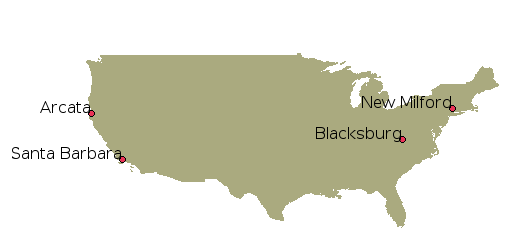
And now you've got a shapefile of the geocoded cities!

The txt2shp.py script can be downloaded here. Try it out and let me know how it's working for you.
Update: In order to generate a .prj file for your output shapefile, you can use the epsg_tr.py utility if you know the EPSG code. Batch Geocoder returns everything in lat/long (presumably with a WGS84 datum?) so you can use EPSG code 4326:
epsg_tr.py -wkt 4326 > cities.prj